
 Hurricane Risk in El Paso, TX
Risk Level: Low — Score 1/10
Live Hurricane alert status near El Paso
Checking live hurricane alerts near El Paso…
refreshes every 15 minutes · DisasterAWARE live feed · all active hurricane alerts in the US →
Recent hurricane activity near El Paso
Last 30 days · updated 2026-09-30 · alerts are forecast products; an observed event is stated as such.
Mon Sep 28, 2026, 12:00 PM MDT – cancelled Wed Sep 30, 1:50 AM MDT · All of El Paso County, plus Hudspeth County and southern New Mexico
Hazard: Heavy rain and flash flooding from Polo's tropical moisture, plus a Wind Advisory for gusts up to 55 mph.
Polo never reached El Paso as a tropical storm. It made landfall on Baja California Sur's west coast late Monday, just south of Las Barrancas (NHC advisory 34A; NHC later estimated it was a Category 2 hurricane at landfall), crossed the Gulf of California, and came ashore again late Tuesday morning a little east of Guaymas, Sonora, at 75 mph (advisory 36A). It weakened to a tropical storm by 2 PM MST (advisory 37) and NHC declared it dissipated over northwestern Mexico at 8 PM MST Tuesday (9 PM in El Paso), about 125 miles southwest of El Paso; that was NHC's last advisory (38). NHC said its remnants were still producing heavy rain and gusty winds over parts of the southwestern U.S. that evening. While the watch was in effect, NWS El Paso issued three flash flood warnings that included parts of El Paso County: El Paso's east side Monday evening (7:02–8:29 PM), northwest El Paso County including Canutillo, Westway and Vinton Tuesday afternoon (4:10–5:45 PM), and the far southeastern county near Fort Hancock Tuesday night (9:24 PM–12:30 AM). It also issued four flood advisories for the county (three Monday evening and night, one Tuesday 3:16–4:15 PM), a severe thunderstorm warning for northwestern El Paso County Tuesday afternoon (3:33–4:15 PM), and the Wind Advisory, which ran from 3 PM until it was cancelled at 10:40 PM Tuesday. NWS cancelled the watch at 1:50 AM Wednesday, about four hours early, saying additional flooding was not expected. The watch was first issued late Saturday, September 26.
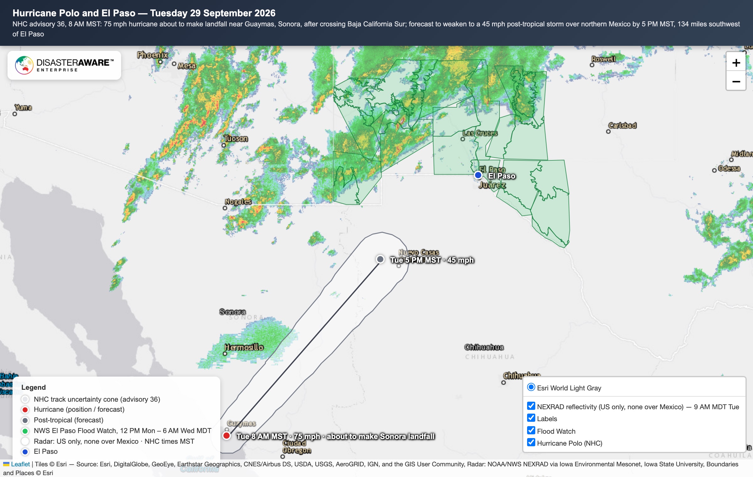
Tue Sep 29, 2026, 4:00 PM MDT – 4:19 PM MDT · Northwest El Paso County (Vinton, Anthony) and El Paso
Hazard: Thunderstorm downpours in the moisture from Polo's remnants.
Flooding was reported to NWS Tuesday afternoon: South Desert Blvd was closed by flooding near Vinton, water was running over S. Desert Blvd at Anthony (TxDOT camera), and a trained spotter reported flooding at Harrison and Alabama streets in El Paso deep enough to stop traffic. Thunderstorm winds also brought down power lines and utility poles near Rushing Road and Fairbanks Drive in northeast El Paso. El Paso International Airport measured 0.72 inch of rain Monday and 0.09 inch Tuesday, with a peak gust of 43 mph Tuesday. Gauges in NWS El Paso's Wednesday-morning rain report ranged from 0.59 to 1.58 inches across the county, the most about 5 miles north of El Paso. No flooding was reported to NWS in El Paso County from Monday evening's warning or Tuesday night's warning near Fort Hancock (Local Storm Reports checked 2026-09-30).
Live hurricane map around El Paso
Shows hurricane warnings and events that are active right now, refreshed through the day. When none are active, the map is empty by design — the section above is what happened recently.
Key Risk Factors
Hurricane risk in El Paso is rated low (1/10). DisasterAWARE's historical archive has no recorded hurricane events near El Paso, and forward-looking hazard models identify no significant hurricane risk factors for this location. Low risk does not mean unmonitored: DisasterAWARE tracks hurricane activity worldwide in real time, so any future alert affecting El Paso appears the moment an authoritative agency issues it.
Peak season: August-October
Highest Risk Cities for Hurricanes
How El Paso Compares
Hurricane Preparedness Tips
- 1.Know your evacuation zone and plan routes in advance
- 2.Install storm shutters or have plywood pre-cut for windows
- 3.Stock at least 3 days of water, food, and medications
- 4.Secure outdoor furniture and trim trees near structures
- 5.Review your insurance coverage for wind and flood damage
Related Pages


How this data is built
El Paso, TX hurricane risk combines Historical Event Intelligence with authoritative hazard modeling from the Geospatial Intelligence Layers catalog. Live hurricane monitoring is available through the Event Intelligence API and the DisasterAWARE Platform.
The data behind this page
Every score and event here comes from DisasterAWARE's hazard database — available as downloadable historical datasets and a real-time API.
Monitor Hurricane Risk in Real Time
Get real-time hurricane alerts for El Paso, TX and hundreds of other locations with DisasterAWARE's enterprise platform.