
 Tornado Risk in Columbus, OH
Risk Level: Very High — Score 7/10
Live Tornado alert status near Columbus
Checking live tornado alerts near Columbus…
refreshes every 15 minutes · DisasterAWARE live feed · all active tornado alerts in the US →
Recent tornado activity near Columbus
Last 30 days · updated 2026-09-25 · alerts are forecast products; an observed event is stated as such.
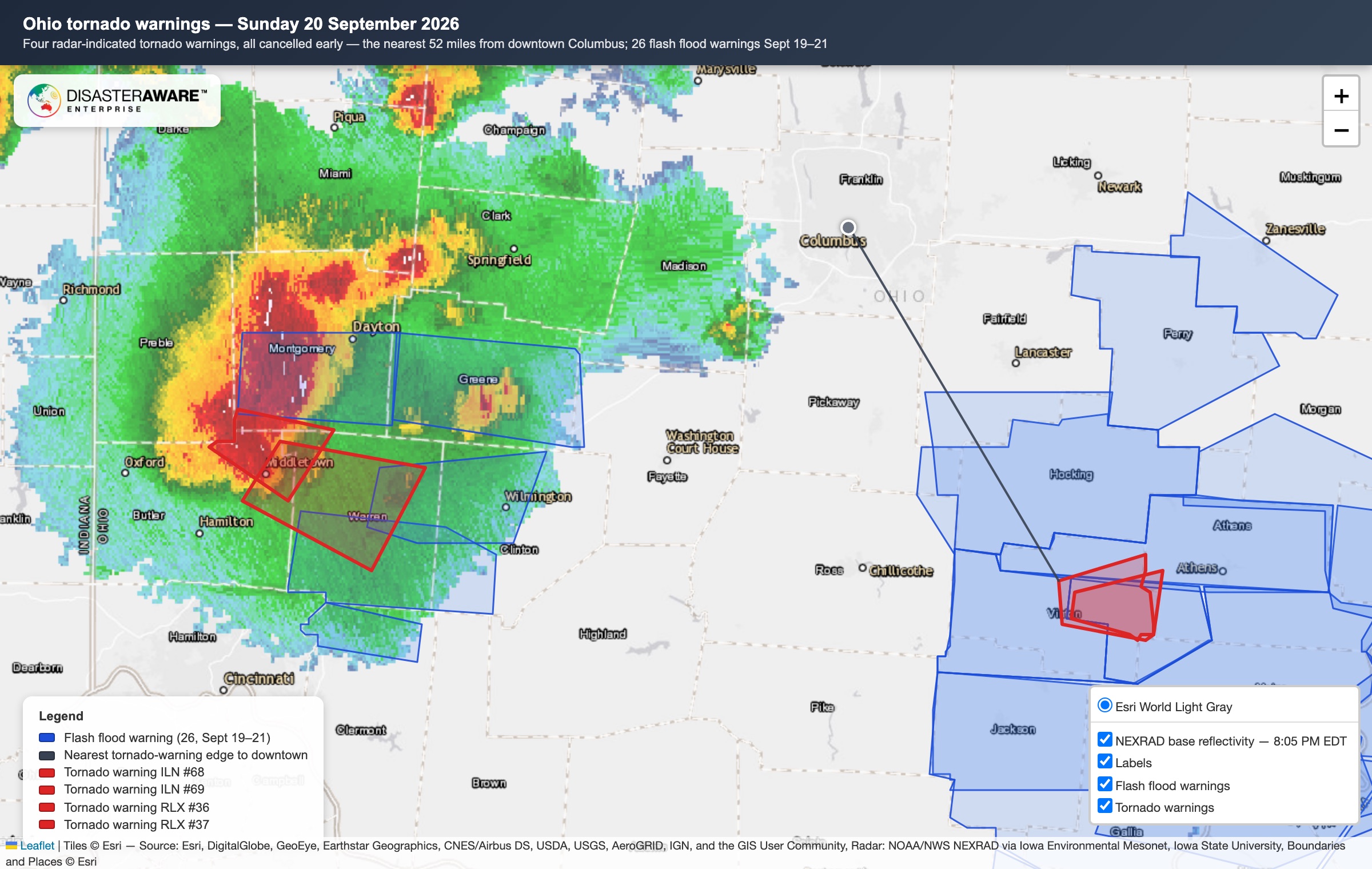
Sun Sep 20, 2026, 7:54 PM EDT – 11:14 PM EDT · Butler, Warren and Montgomery counties (NWS Wilmington, 2 warnings); Vinton and Athens counties (NWS Charleston, 2 warnings) · about 52 mi from downtown
Hazard: Tornado, from radar-indicated rotation.
Franklin County was not inside any of them: the nearest, over Vinton County, was about 52 miles southeast of downtown. NWS cancelled all four early. No tornado was reported anywhere in Ohio from September 19 through 22 (NWS Local Storm Reports, checked 2026-09-25); that night's damage reports were trees downed by thunderstorm winds, mostly between Dayton and Lebanon in southwest Ohio. For Columbus itself the weekend brought only a Flood Watch. The real hazard was water to the south and east: NWS issued 26 flash flood warnings across Ohio from September 19 to 21, with water rescues in Hocking, Vinton and Athens counties.
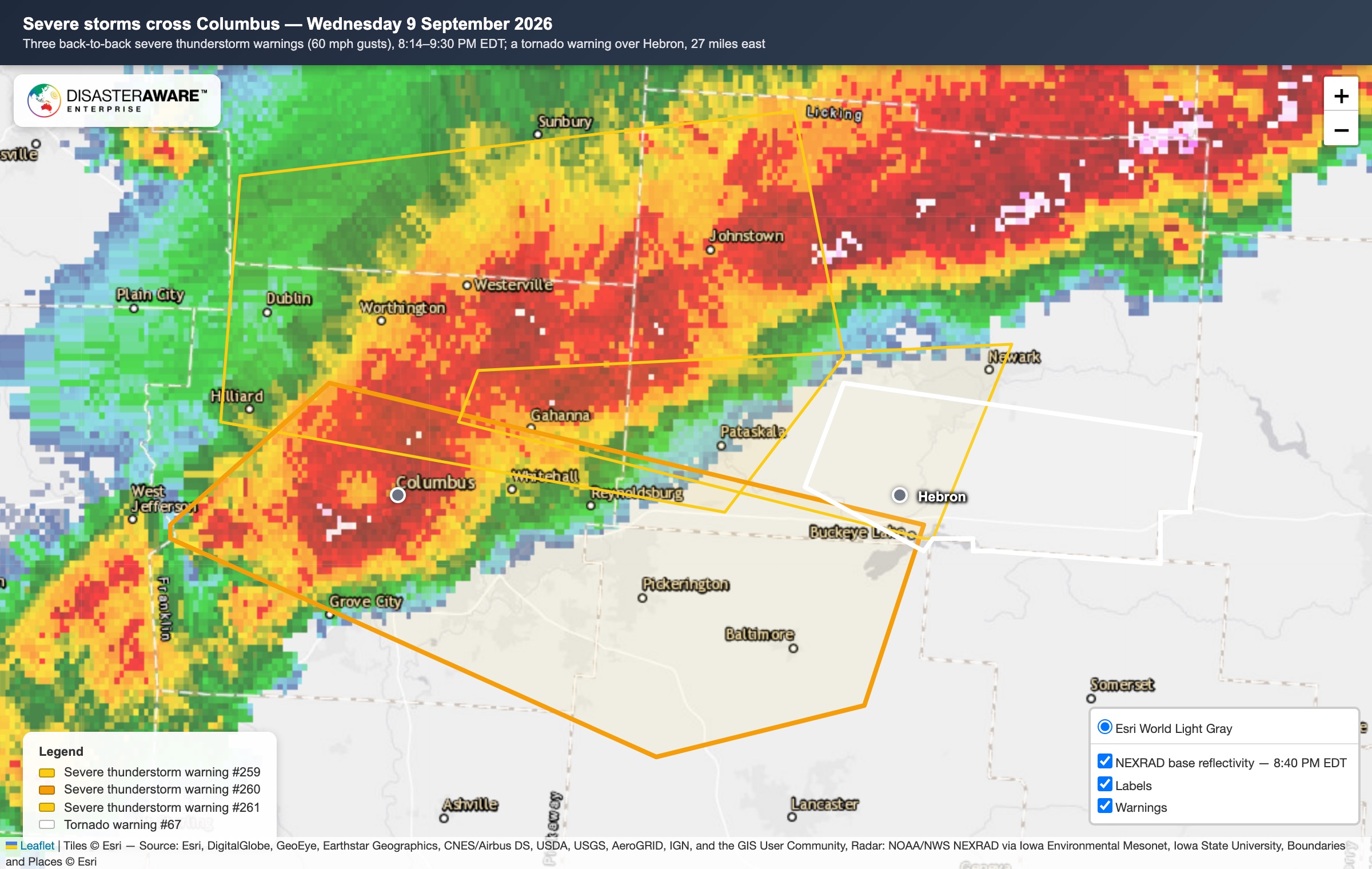
Wed Sep 9, 2026, 8:36 PM EDT – 9:15 PM EDT (39 min) · Franklin, Licking and Fairfield counties, including downtown Columbus
Hazard: 60 mph wind gusts.
The only warning in the last 30 days whose area included downtown: a line of storms crossed the city from Dublin through the Ohio State campus to Gahanna at about 45 mph, under three back-to-back severe thunderstorm warnings (8:14 to 9:30 PM EDT). NWS logged no damage reports in Franklin County; the nearest was a single tree down in Powell, Delaware County. The same storm prompted a radar-indicated tornado warning over Hebron in Licking County (8:57 to 9:30 PM EDT), about 27 miles east of downtown, which expired with no tornado reported there. The only tornado reported in Ohio that night was a preliminary report about 4 miles east of New Concord in Guernsey County, roughly 70 miles east of Columbus.
Live tornado map around Columbus
Shows tornado warnings and events that are active right now, refreshed through the day. When none are active, the map is empty by design — the section above is what happened recently.
Key Risk Factors
- FEMA rates Columbus's county as Relatively High risk
- Estimated annual loss of $29M from this hazard type
- 36 tornadoes within 50 km since January 2015 (3 rated EF2 or stronger; 2026 figures provisional)
- 5 tornadoes within 50 km in the 12 months to Sep 30, 2026 (2026 figures provisional)
- Occurs roughly 0.29 times per year on average
Peak season: April-June
Last significant event: EF2 tornado on March 14, 2024, closest point 39 km from the city centre (no deaths or injuries recorded)
Highest Risk Cities for Tornados
How Columbus Compares
Strongest Tornadoes Near Columbus
36 tornadoes touched down within 50 km of Columbus between January 2015 and September 30, 2026 (3 rated EF2 or stronger), according to NWS and SPC tornado records. 2026 figures are provisional until SPC publishes its final 2026 tornado file, and September 2026 is preliminary while NWS damage surveys are completed. The 5 strongest are listed below; distances run from the city centre to the closest point of each tornado's path (start to end point).
EF2 tornado, 21.1-mile path, closest point 34 km from the Columbus city centre
February 28, 2024 — EF2
3 injuries
EF2 tornado, 19.5-mile path, closest point 39 km from the Columbus city centre
March 14, 2024 — EF2
No deaths or injuries recorded
EF2 tornado, 14.0-mile path, closest point 17 km from the Columbus city centre
February 28, 2024 — EF2
No deaths or injuries recorded
EF1 tornado, 35.4-mile path, closest point 31 km from the Columbus city centre
March 14, 2024 — EF1
No deaths or injuries recorded
EF1 tornado, 12.3-mile path, closest point 16 km from the Columbus city centre
February 28, 2024 — EF1
No deaths or injuries recorded
Tornado Preparedness Tips
- 1.Identify a safe room or storm shelter in your home or building
- 2.Practice tornado drills — get low, cover your head, stay away from windows
- 3.Have a NOAA Weather Radio for tornado watch and warning alerts
- 4.Secure outdoor objects that could become projectiles in high winds
- 5.Know the difference between a tornado watch and a tornado warning
Related Pages


How this data is built
Columbus, OH tornado risk combines Historical Event Intelligence with authoritative hazard modeling from the Geospatial Intelligence Layers catalog. Live tornado monitoring is available through the Event Intelligence API and the DisasterAWARE Platform.
Free from DisasterAWARE
A morning tornado report for Columbus, OH and up to four other places
TornadoAWARE emails you each morning what tornado and severe-weather activity touched the places you care about, with the history of what has hit there before. No app, no account: an email address and your places.
The data behind this page
Every score and event here comes from DisasterAWARE's hazard database — available as downloadable historical datasets and a real-time API.
Monitor Tornado Risk in Real Time
Get real-time tornado alerts for Columbus, OH and hundreds of other locations with DisasterAWARE's enterprise platform.